- Home
- Understanding aviation noise
- Noise mapping
Noise mapping
When making decisions concerning land-use planning, changes in air tracks, traffic distribution and others, stakeholders are often presented with their impact on noise exposure as presented in noise contours.
State-of-the-art tools generate information on noise exposure following a predefined and standard methodology defined in the Environmental Noise Directive (END) and Doc. 29 ECAC/CEAC – guidance on the calculation of aircraft noise exposure levels and the production of aircraft noise contours. Although this is relevant for planning purposes, it falls short when airport noise issues need to be managed at a detailed level. As highlighted by the ANIMA project, an understanding of people's reaction to interventions aimed at reducing the noise impact is required to maximise the benefits of such interventions.
Noise contours for a particular airport are typically produced as a part of a noise impact assessment of some kind. The requirements can vary widely depending on the nature of the intervention under consideration. The assessment of different noise indicators, including different tracks, different aircraft, different traffic, different airport configurations, could be necessary for properly evaluating the intervention. Moreover, perception indicators start to be essential for airport noise evaluations.
The END methodology on the calculation of aircraft noise exposure levels and the production of aircraft noise contours (noise footprints) follows this scheme:
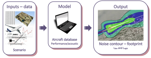
Data needed for generating scenarios | How the data will be used to generate the output (noise contours) |
Airport – geometrical and spatial definition of runways, platforms and taxiways | To generate the scenario |
Routes – air routes, airways, tracks information | To generate the scenario |
Aircraft – aircraft types which were used during the assessed year (helicopters and light aircraft must be included) | To simulate the scenario |
Procedures – usage of elements (runways and airways for air noise, runways and taxiways for ground noise) | To simulate aircraft movements over the elements |
Traffic – aircraft kind and number per year in the airport | To simulate the actual amount of traffic |
Weight – the weight used in each procedure in one year per aircraft kind. The "typical day" is a "virtual day" built with different annual weightings | To simulate the flights of a "typical day", together with the annual traffic weight, aircraft kind, dispersion, etc. |
Dispersions – horizontal and vertical. Assessed year's aircraft procedures (statistical or actual) | To generate flight simulations closer to the actual operations |
Geophysical data – urban areas and buildings | To assess noise propagation |
Population – number of people during the assessed year | To assess noise effects |
Meteorology – temperature, environmental pressure and humidity (assessed year's average) | To assess noise propagation |
The noise contour calculated according to END methodology is used by airports to identify areas qualifying for insulation schemes, define land-use planning rules, noise protection zones and to communicate noise exposure data to the European Commission in a coordinated way.
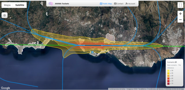
Nevertheless, the tools and the noise contours can be used to assess interventions using different noise indicators, tracks, aircraft, traffic or airport configurations with the goal to obtain simulated noise results for different scenarios. The Noise Management Toolset shows some examples prepared for a virtual airport.